Haitian Earthquake: Links for January 22
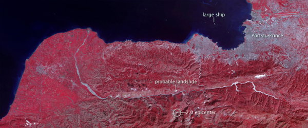
This false-colour image of Haiti was taken by the ASTER instrument on NASA’s Terra satellite yesterday.
The 15-cm-resolution imagery I mentioned in an earlier entry is available for download from Google; the very large files are intended for GIS professionals. GeoEye-1 imagery is also available.
A Bing Maps application allows you to toggle between pre- and post-earthquake imagery.
More on OpenStreetMap. Harry Wood on the use of OSM in Haiti (via Peter); another page of video tutorials, one of which we’ve seen before (via geoparadigm). Information on using OSM data within ArcGIS (via geoparadigm).
Paper maps are still relevant to relief efforts: the U.S. military has produced thousands of paper maps, which were sent to units on the ground (via All Points Blog.
A story about Boston University students producing maps of the Haitian earthquake (via MAPS-L).
Previously: Haitian Earthquake: Links for January 20; Haitian Earthquake: Links for January 16; Haitian Earthquake: Links for January 15; ESA Satellite Imagery of Port-au-Prince; Mapping the Destruction in Port-au-Prince; Mapping the Haitian Earthquake.

Comments
blog comments powered by Disqus