Joshua Miele’s Tactile Maps
Bill Warren wrote to me earlier this month:
On May 8th, the California Map Society held a meeting at Stanford University in Palo Alto, CA. One of the speakers was Joshua Miele, Ph.D., Associate Scientist at the Smith Kettlewell Eye Research Institute’s Rehabilatation Engineering Researcn Center in San Francisco. His topic was Automated Production of Tactile and Audio/Tactile Maps. In other words — Maps for the Blind.
What sounds like an impossibility is already in production and Dr. Miele, who incidentally is totally blind, held the audience enthralled with the description of his development of a web-based software tool for the rapid production of tactile street maps. The attached photo shows such a map with a centered location grid locating the intersection of 14th and Broadway in Oakland, CA. Around the periphery are three digit Braille street name abbreviations. The raised street grid allows the blind user to quickly understand the street patterns and orient themselves. Even complex intersections can be easily portrayed and understood.
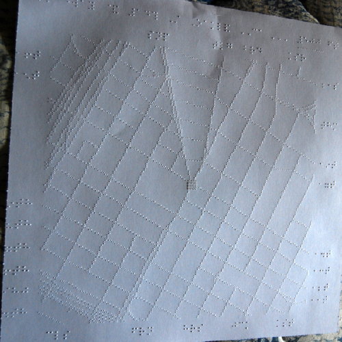
The map is not meant to carried but portions can be quickly memorized by the user. Not all streets are named, but each street is shown so the number of blocks between named streets is obvious to the user. Dr. Miele’s talk was as a self assured scientist putting his life’s work to use for others whose needs he understands. At the end of his presentation the audience gave him a richly deserved ovation.
Links added. Here is the website of Dr. Miele’s tactile map project.
Previously: A View of Prague for the Blind; Virtual 3D Maps for the Blind; Maps for the Visually Impaired; Maps and Directions for the Blind; Online Maps for the Visually Impaired.

Comments
blog comments powered by Disqus