Louis XIV’s Scale Models
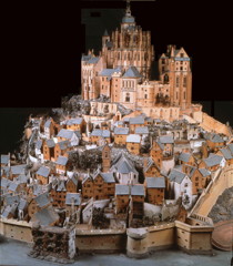 I always enjoy reading Jeffrey Murray’s articles in Fine Books and Collections magazine, and his latest, on the three-dimensional scale models made of military fortifications and cities for Louis XIV and his successors, is no exception: it’s a fascinating look at a way of visualizing places in three dimensions that began two centuries before 19th-century bird’s-eye city illustrations. Via MapHist.
Previously: The Making of the Atlantic Neptune; World War I Trench Maps.

Comments
blog comments powered by Disqus