Visualizing Sea Ice
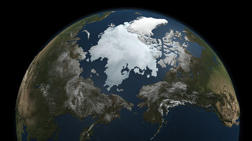
This image of sea ice at the North Pole is not a photo. It’s compiled from microwave data gathered by the Aqua satellite’s AMSR-E microwave sensor. “Ice emits more microwave radiation than water, making regions of the ocean with floating ice appear much brighter than the open ocean to the AMSR-E sensor. This difference allows the satellite to capture a sea ice record year-round, through cloud cover and the months of polar night.” The data for this image was collected on September 3; the annual minimum will take place later this month. Image credit: NASA/Goddard Space Flight Center Scientific Visualization Studio.

Comments
blog comments powered by Disqus