Typographic Maps of Boston and Chicago
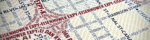
Andy Woodruff announces a new project from Axis Maps: typographic maps — “that is, maps made entirely of typography.” Map features are rendered in repeating lines of type (see example above).
Nearly every line of text in these maps was laid out manually. And after that, nearly every line was edited manually to create effects such as the appearance of woven streets. It was all done in Illustrator, beginning with images from OpenStreetMap. We traced streets, filled in areas like water and parks, and then revisited every detail. In this process I think we’ve learned a few things that will help us generate maps of some other cities without taking two years to do it.
Two maps for Boston and one for Chicago so far, prints of which they’re selling. Via Geoparadigm.

Comments
blog comments powered by Disqus