Mapping the Haitian Earthquake
This post will be updated as needed.
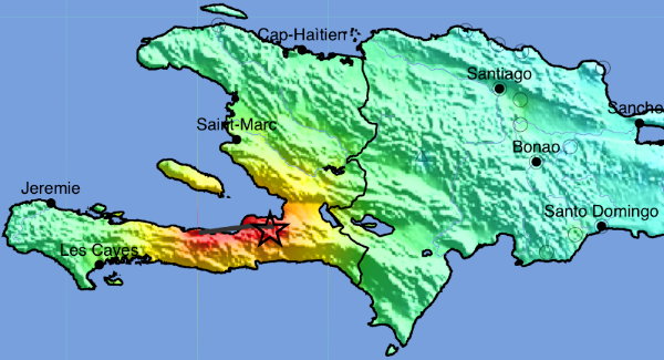
Earthquake maps of Haiti and the surrounding area from the U.S. Geological Survey’s Earthquake Hazards Program; these include the ShakeMap (above), which maps the intensity of the quake.
Google reports that they’re working on getting post-quake imagery from its satellite imagery providers, and will update when that is available.
10:05 AM:
Google Maps Mania has a roundup of earthquake maps.
11:04 AM:
David Fawcett writes: “[Y]ou may want to mention the OpenStreetMap effort to provide improved data to support the response.” Here’s the link.
1:36 PM:
Geotagged photos on Flickr from Port-au-Prince tagged with “earthquake” should turn up on this map.
2:44 PM:
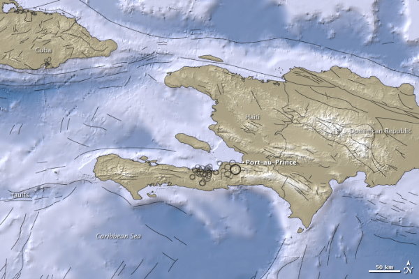
NASA’s Earth Observatory has released this relief map of the affected area: “Black circles mark earthquake locations determined by the USGS, and circle sizes correspond with quake magnitudes. Black lines indicate fault lines.”
Also, Kathryn Cramer points to a map of Haitian landmarks (KML) that she assembled for the 2006 elections, which may be useful in establishing points of reference.
3:55 PM:
GIS Lounge’s Haiti Maps and GIS Data Resources.
4:31 PM:
Two map mashups produced using GeoCommons Maker: this one combines USGS ShakeMap data with population density data; this one maps geotagged Flickr photos and crowdsourced Ushahidi reports.
5:24 PM:
James posts an awe-inspiring list of community geospatial links about the Haiti situation; he says this about that: “Many companies are using this disaster to showcase their products and I think we need to try and share this open data outside of these silos.”
6:29 PM:
Google Earth Library: “I’ve tried to bring together the various maps and other data related to the Haiti Earthquake into a single location and in a format that can be easily viewed by anyone with Google Earth. I will continue to update this post as I find more maps or other data. The new maps should automatically appear on your computer as I add them.” KML link.
Via Free Geography Tools and Very Spatial: humanitarian field mapping NGO MapAction (previously) has announced that it’s deploying a four-person team to Haiti to gather information on the ground.
6:32 PM:
NASA’s Earth Observatory maps the topography along the Enriquillo-Plaintain Garden Fault south of Port-au-Prince, site of the quake’s epicentre.
7:23 PM:
Google says it has received satellite imagery for Port-au-Prince, taken this morning, and that they’re working to get it into Google Earth as soon as possible. Also, they’ve made raw Map Maker data available to the U.N.
11:14 PM:
Post-earthquake satellite imagery of Port-au-Prince is now available as a KML layer for Google Earth.
Jan. 14, 11:41 AM:
Haiti earthquake data, comprising free GIS datasets and online resources related to the Haiti earthquake, from Harvard’s China Earthquake Geospatial Research Portal.
5:12 PM:
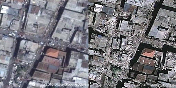
The Big Picture’s second entry on the earthquake includes some aerial photography of the devastation in Port-au-Prince, which I think is far more telling than even high-resolution satellite imagery.
Mikel notes that more than 400 edits have been made to Haitian data on OpenStreetMap since the earthquake, and has before and after images of OSM’s Port-au-Prince maps.
Jan. 15, 8:15 AM:
OpenRouteService for Haiti, which provides street routing where destroyed traffic infrastructure can be marked and avoided.
8:48 AM:
New posts: Mapping the Destruction in Port-au-Prince; ESA Satellite Imagery of Port-au-Prince.
11:38 AM:
New post: Haitian Earthquake: Links for January 15. Further updates will now come in new entries. See the Haitian Earthquake category.

Comments
blog comments powered by Disqus