Haitian Earthquake: Links for January 20
Satellite and Aerial Imagery

Last night, Google released imagery of Port-au-Prince at even higher resolutions (15 cm) than before (above). The images were taken on Sunday, January 17, and will be available in Google Maps, in Google Earth by some time today, and directly to relief organizations. Google has also released a KML file that allows you to toggle between imagery taken before and after the earthquake, and has updated the Haiti Earthquake KML layer.
Recent releases of NASA satellite imagery have focused on the potential for landslides near the epicentre. See Earth Observatory and images the ASTER instrument abaord the Terra satellite, taken on January 14, and the EO-1 satellite, taken on January 15.
DigitalGlobe is offering free access to its Haiti earthquake imagery, presumably to appropriate parties. Via geoparadigm. DigitalGlobe imagery is also available via Bing Maps, which in turn is available through ArcGIS. Via geospatialnews.
Community Mapping
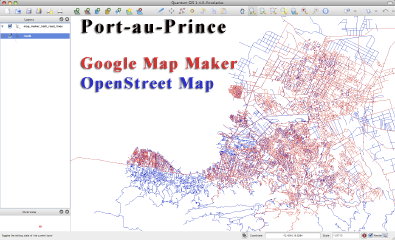 Community mapping has produced a huge amount of new map data for Haiti, but, as Sean Wohltman points out, it’s being split between Google Map Maker and OpenStreetMap.
But OSM and Map Maker aren’t talking and I think it is a big problem — if you want to help rescue efforts in Haiti where do you go to digitize? OSM? Map Maker? … As it stands right now, even though the MapMaker data is free for non-profit use, projects like OSM can’t use the data because there are commercial uses for OSM and the data belongs to Google, not OSM.
Sean has maps showing the coverage from each, how they overlap and how they differ (above right). Via Off the Map. Muki Haklay tries to square the circle by selecting between Map Maper and OSM on an area-by-area depending on which has better coverage for a given area; via Dave Smith.
More on OSM and Haiti. Here’s a video tutorial on how to add roads for Haiti in OSM by tracing them from satellite imagery; via geoparadigm. Mikel reports that Flickr is using OSM tiles for Haiti.
Links to Resources
All Points Blog and Google Earth Blog have additional collections of links to mapping resources for Haiti.
Previously: Haitian Earthquake: Links for January 16; Haitian Earthquake: Links for January 15; ESA Satellite Imagery of Port-au-Prince; Mapping the Destruction in Port-au-Prince; Mapping the Haitian Earthquake.

Comments
blog comments powered by Disqus