Monday, July 28, 2003
Garmin iQue 3600 Now Shipping
As Silus Grok writes and Gizmodo notes, Garmin’s iQue 3600 is now shipping, though in limited quantities. I’ll be looking forward to reading the reviews. (See previous entries: Maps on Your PDA, Garmin iQue 3600 Photos, Enough About That Garmin PDA Already, Jon)
Friday, July 25, 2003
The Countryside Agency
“The Countryside Agency is preparing maps of all open country and registered common land in England.
Thursday, July 24, 2003
SDDS High-Resolution Digital Maps
The USGS’s Seamless Data Distribution System (SDDS) allows you to zoom in on high-resolution orthoimagery for a few U.S. cities, with more added all the time. Resolution so good that Michael Hall can see his car parked in his driveway — um, remind me why this is a good thing again? But I digress. Rail lines, highways, county boundaries, street names and topography can be overlaid on the images. It’s most useful when you choose an area with high-resolution imagery; don’t make the mistake I did at first and click on North Dakota — that won’t get you anywhere. (via MetaFilter)
More on GPS Uses
Last Tuesday’s Edmonton Journal had a rather basic, introductory article on real-world applications of GPS technology. (See previous entry: GPS’s Ever-Increasing Usefulness)
Wednesday, July 23, 2003
Library Journal Online Map Guide
Ann Jason Kenney is a high-school librarian from Vermont who writes to direct our attention to an article she wrote for Library Journal, published last fall, that outlines some of the better online cartographic resources out there. Definitely worth checking out.
Monday, July 21, 2003
Cambridgeshire Map Exhibition
A new exhibition at Cambridge’s University Library, Unfolding Landscapes: Maps of Cambridgeshire from Elizabeth I to Elizabeth II:
This exhibition traces the key events in the mapping of the County from 1573 to 2003, right up to the Ordnance Survey digital maps of today. On display are printed maps illustrating the evolving styles of cartography, prompted and inspired by technical advances and changes in the use to which maps are put. Apart from maps of the whole County, the exhibition looks at the mapping of Cambridge and the Fens.
(via Owen)
Sunday, July 20, 2003
Geography at About.com
Matt Rosenberg is the Geography guide for About.com. He writes to tell us about About.com’s Geography site, naturally. “Hi Jonathan! I wanted to let you know that I added a link to your site from my site at http://geography.about.com/cs/cartography/. I hope you’ll take a look at my ‘geography blog’ on my home page.” There’s some good material on both pages: the geography blog covers more than just cartography and is quite interesting; the cartography page has a number of core reference links that look like they’re worth pursuing. Have at it.
Matt adds, as an aside, “My favorite online map is the USGS’s Recent Earthquakes in California map.”
Saturday, July 19, 2003
PureCanada Update; Regional Reactions
The Canadian Tourism Commission has accepted responsibility for the map errors in the first issue of its PureCanada magazine; it had previously blamed Fodor’s for the mistakes. Additional coverage at CBC News. (See previous entries: Off the Map, Out of Mind; PureCanada Map Errors)
A roundup of coverage of this story that I missed in previous posts, including some really miffed local coverage from areas left off the maps:
- All mapped out (editorial, Sault Star, July 17)
- Tourism guide gaffe a positive for Sault, Rowswell contends (Sault Star, July 17)
- Commission was warned about missing Yukon (Whitehorse Star, July 16)
- Information in tourism mag seems decades old (CBC North, July 16)
- Missing Island “shoddy” work: Tourism minister (Journal-Pioneer, July 16)
- Publisher apologizes for gaffes on map: Cities, provinces not on tourist guides (National Post, July 16)
- Travel magazine leaves P.E.I. off the map (Halifax Herald, July 16)
- “A few things slipped through”: $600,000 project uses Fodor’s maps (National Post, July 15 — check out the reader comments)
- Maps to promote Cdn. tourism filled with errors (CTV News, July 15)
- Yukon dropped from tourism map of Canada (CBC North, July 15)
Are there any lingering doubts about how politicized mapmaking can be in a country with, to paraphrase one of its former prime ministers, too much geography and too little history?
Friday, July 18, 2003
British Library Map Collections
Owen writes: “I’m pleased to see that The Map Room is going from strength to strength. You might enjoy the digitised maps offered by the British Library
Ordnance Survey Drawings: “The original large-scale drawings made for the famous one-inch-to-the-mile maps present a detailed picture of England and Wales between the 1780s and 1840.”
Crace Collection of Maps of London: “This is the essential guide to the development of the capital from the 16th to the 19th centuries, brought together by the Victorian designer, Frederick Crace.”
Lewis & Clark at the Library of Congress
Todd writes to tell us about a new exhibition at the Library of Congress: Rivers, Edens, Empires: Lewis & Clark and the Revealing of America. The Exhibition Preview has lots of good, interesting material. (See previous entry: Lewis and Clark)
James Turner Explains What He Does
James Turner writes in to explain what he’s doing here and here:
I noticed you had referred some traffic through to my site and tracked back to your map room where you had referenced my map project. I think it was some time ago but I thought, as a fellow map aficiando, I’d forward on what the piece is about:
Map of Humanity
Maps organize information. They pinpoint geographic locations relative to each other. The Map of Humanity also organizes information, but instead of doing it geographically, the map organizes the locations on the basis of moral, emotional, and cultural significance.
From the mythical cradle of human thought in the Garden of Eden, to the farthest reaches of human imagination, the map plots out mankind’s achievements, trials, and tribulations throughout history. We have constructed a world made up of our own actions and beliefs, as much as the one formed by the land we live on. The map of humanity is formed by our thought, our feelings, our dreams, and our nightmares.
The continents of this restructuring rest upon the sea of the unconscious, the stormy basis of our thought. The land that emerges from it is broken into three main continents, each related to an aspect of the human mind: superego, ego, and id.
The superego is dominated by our higher aspirations. It is our moral centre, where our sense of compassion, love, and virtue reside. Hope, family, kindness, and beauty dwell here amongst the peaceful fields and tranquil cities.
The ego is dominated by reason, rational thought, and order. It is the land of science, where nature is harnessed by the human mind; and order and reason hold sway over emotion and passion.
The id is the dark continent, dominated by our primitive, animalistic urges. Here hate, greed, avarice, lust, and bigotry run rampant, and war devolves into atrocity.
This is the world of our making, carved out of our actions, built upon the collective achievements of the human race.
It is an attempt to map the last six thousand years of human history and thought upon a theoretical geography to discover a sense of what kind of civilization humanity has attained. And like the geography of human nations, it is in constant flux, changing and growing as long as mankind walks the face of the earth.
It took over a year to research, continues to expand as I add new places, took 5 months to build, has thousands of locations based on history and fiction. Mammoth project, at least for me. I’m trying to get the thing published but publishers are not cooperating. The struggle continues!
Thanks for the link and have a great day!
(See previous entry: James Turner Illustration; see also: Doctored Maps)
Thursday, July 17, 2003
Barrington Atlas
The Barrington Atlas of the Greek and Roman World is the first historical atlas of the classical period since the 19th Century. At US$350, it’s kind of expensive (Amazon), but, from what I’ve been able to see, it’s astonishingly beautiful. Do not be confused by the existence of this two-volume set for US$150, which is simply a paper copy of the directory included as a CD-ROM with the atlas. More links at, and via, MetaFilter.
New York Ethnicity
A map of New York’s ethnic composition in 1996, from a Gotham Gazette feature in August 2000. My, but Staten Island is white. (via Kottke’s Remaindered Links)
Mac Mapping Software
The state of mapping software on the Macintosh is sufficiently dire (much to my chagrin) that people must to resort to using Virtual PC so as to run PC software in emulation — which is not without its problems. Garmin GPS users can use MacGPSPro to connect up their GPS receiver to their Macs, but it doesn’t offer the same functionality as Garmin’s own (Windows) software. (I wonder if this will have any bearing on the Mac compatibility of the iQue 3600? Must investigate.) If you’re interested in discussing mapping and GPS software on the Mac, there is a mailing list.
Wednesday, July 16, 2003
Off the Map, Out of Mind
Being left off a map can be tantamount to saying that you don’t belong, or don’t matter. We’ve read about the Canadian Tourism Commission’s erroneous maps in its inaugural issue of Pure Canada, which, among other things, left out most of northern Ontario. For Bob Woito of Marathon, Ontario, it’s one more reason that northern Ontario should separate from the rest of the province.
Railroad Atlases
I’m interested enough in railroads that I wouldn’t mind seeing maps of the various rail lines’ networks. A couple of years ago I made a furtive bid on an eBay auction of a railroad atlas — something I’d never heard of before but which sounded interesting: maps of all the railroad lines on the continent. I didn’t win the auction because I didn’t appreciate how expensive railroad atlases actually are. At US$70-75, Rand McNally they ain’t: they’re professional-level references. Altamont Press sells one; they also have a map and atlas section. DeskMap Systems sells the same atlas, but also sells full-sized printed maps, which look interesting, and databases, which are no doubt useful in the industry.
But I’m not in the industry, and, unless I’m mistaken, neither are you. For the rest of us, Amazon.com lists some railroad atlases, but most of them are out of print. And for those of us disinclined to spend any money, I’ve saved the best for last: the P-FMSIG has scanned a 1948 Rand McNally railroad atlas that can be viewed by state, with some city and regional maps thrown into the mix as well.
Warning: Post-Modern Theoretical Paper Ahead
Anna Oliver’s Barthesian take on artist Simon Patterson, who used a map of the London Underground in a 1992 work entitled The Great Bear (via rodcorp). No points taken off if you’re bewildered: I am, and I studied Barthes in university.
Tuesday, July 15, 2003
The Barren Lands
The Barren Lands: J. B. Tyrell’s Expeditions for the Geological Survey of Canada, 1892-1894 is a magnificent online collection.
This site documents two exploratory surveys of the Barren Lands region west of Hudson Bay, in northern Manitoba and Saskatchewan and the area now known as Nunavut. Drawing on materials from the J.B. Tyrrell, James Tyrrell and related collections at the Thomas Fisher Rare Book Library, University of Toronto, it includes over 5,000 images from original field notebooks, correspondence, photographs, maps and published reports.
What’s especially interesting (and relevant to our interest) is the map-based navigation on the site. Click on Expedition Maps, choose one of the expeditions, and zoom in to the point where each day of the Tyrells’ travels is marked on a map. Clicking on the date takes you to the digitized documents related to that date. Neat, neat, neat stuff. (via Manifesto Multilinko)
Monday, July 14, 2003
Geocaching; The Degree Confluence Project
So much for treasure maps. The San Francisco Chronicle has a feature about “geocaching” — essentially a high-tech treasure hunt using GPS receivers to find previously hidden caches.
What would cause two grown men, one (Grenewetzki) the former president of a video game company and the other the 46-year-old owner of a Petaluma plumbing company, to hide treasures from each other? To drive around Marin County, one holding a GPS aloft and the other consulting his own GPS as well as a PDA?
Blame it on geocaching, an Internet-based hide-and-seek game that has, just three years after its invention, been played by an estimated 250,000 people around the world. Roughly 15,000 play in any given week, and the number has doubled about every six months, said Jeremy Irish, a 30-year-old Seattle resident who runs the hobby’s Web site (www.geocaching.com).
The article goes on to discuss geocaching’s origins, and mentions some related activities.
Geocaching is a descendant of letterboxing, a similar game — minus the satellite technology — that originated in England in the mid-1800s. It is still played there and, to a lesser degree, in the United States.
Geocaching also is a cousin to orienteering (generally using a map and a compass to navigate a course); volkswalking (noncompetitive walks through scenic areas); and the “Degree Confluence Project,” in which people with GPS units locate and photograph the confluence of longitude and latitude degrees. The project’s Web site (www.confluence.org) reports that of the confluences not in oceans and seas, more than 2,300 have been logged. Just 13,500 remain elusive.
You know, the Degree Confluence Project is easily worth a post on its own; it sounds pretty neat (and seriously nerdy) and should appeal to my map-happy readers.
(via Boing Boing)
PureCanada Map Errors
Douglas Johnston, a lawyer from my home town of Winnipeg, has a bone to pick with the Canadian Tourism Commission about its consumer travel magazine, Pure Canada: the maps, in his view, are all wrong: names out of date or misspelled, larger cities and towns omitted while microscopic settlements are included, entire regions simply not covered. Some of this is just nitpicking: maps routinely fill in the empty spots with smaller settlements, so it’s less of a surprise if smaller northern communities are included and larger southern communities are not. And much of what he complains about is more disagreeing with editorial choices rather than catching outright error.
Sunday, July 13, 2003
DIVA-GIS: Free GIS software
Luigi Guarino writes from Fiji:
Hi there. I find The Map Room really great, a fantastic resource. Thought you might be interested in some GIS software we have been developing specifically to help researchers map biodiversity hotspots and the like. The software is called DIVA-GIS and can be freely downloaded at http://diva-gis.org/. You’ll find some map data there too. The attached article [see below —JC] explains the rationale and workings of a slightly older version of the software. Robert Hijmans, the chief developer, is now at the University of California, Berkeley. Our idea was to develop a cheap, easy-to-use package specifically aimed at biodiversity conservation workers in developing countries, who in general do not have the time and financial resources to devote to off-the-shelf GIS software.
(Luigi enclosed an offprint of an article from Plant Genetic Resources Newsletter in PDF format, which I can forward on request.)
French Cheese Map (Updated)
Florence sends along this map of French cheeses, which, while interesting, as she notes, it isn’t the greatest: it’s clearly scanned from somewhere or other, and its list of cheeses is far from complete.
Update, July 15: The Providence Journal’s Subterranean Homepage News says, possibly half-seriously, this map “looks as though it might have begun life as a decorative dishtowel.”
GPS’s Ever-Increasing Usefulness
This Fast Company article describes GPS as a transformative technology, new uses for which keep getting discovered — and, once discovered, the technology quickly becomes indispensable (via Slashdot). Some of the current (farming, shipping) and proposed (anti-theft, car insurance) uses for GPS are quite novel. And maybe even a bit disconcerting: it’s one thing to be able to track yourself, quite another to be made easier to track by others. (Insert “Brave New World” cliché here.)
Friday, July 11, 2003
Lie of the Land: The Secret Life of Maps
Web content is skewed in favour of the new and the techy, and that doesn’t change when you’re looking for content about maps. Consider recent posts here: posts about antique or historical maps have been outnumbered by those about new mapping technologies. I wish it weren’t the case, and if it wasn’t for Iconomy and plep (and now The Cartoonist), the situation would be even worse (this is a subtle hint for you to keep finding things, people). With that in mind, I was relieved that plep brought to the attention of MetaFilter an exhibition at the British Library that took place in 2001-2002 titled Lie of the Land: The Secret Life of Maps. Wonderful online material, with originals that date back centuries, that makes me wish I could have taken in the exhibit itself — but that’s exactly the page’s intent. Now it’s over. Drat.
Map of Hell
A map of Dante’s Inferno, with a neat little magnifier that you can drag over the map. But its neatness is hindered by the fact that the DHTML used is so outdated (the page dates from 1999) that it works imperfectly at best in modern browsers: the magnifier works in IE 5.2 for Mac, but you can’t scroll the page; you can scroll the page in Safari and Camino, but not use the magnifier. Too bad. (via MetaFilter — plep strikes again!)
Hurricane Maps
The National Hurricane Center produces interesting 3- and 5-day forecast tracks for each tropical storm they monitor; click on “Graphics” for each storm (e.g. Claudette). There are blank tracking maps, in PDF format, at the bottom of the main page as well. (via RAILhead Design)
More Blog Maps
First we had blog maps of London, New York and Washington based on their subway networks (see previous entries: Subway Blogger Maps Redux, The Better to Stalk Your Favourite Blogger By, My Dear). Now there are country-wide blog maps of France francophone blogs in Europe and Japan — obviously not subway-based (via newthings).
Thursday, July 10, 2003
Online Maps� Foot Soldiers
Ever wonder where online mapping services get their data? In many cases, they get it from mapping companies whose employees scour new subdivisions for new, updated or corrected information, as this Washington Post article explains:
Cushing and Clark are among hundreds of people employed to map what passes for a frontier these days. Their job is to visit new developments in Virginia and hitherto undistinguished communities in rural West Virginia. They find horizons in new residential developments in Fairfax County. Or in the ever-shifting exit ramps off the Springfield interchange and near the to-be-rebuilt Woodrow Wilson Bridge.
(via muxway)
Nationmaster
While Nationmaster is not solely dedicated to maps, I’m sure you want me to draw your attention to it anyway: it includes a good amount of basic geographical information (including maps and flags) of each country, and allows you to generate on-the-fly graphs and tables comparing various countries. (Thanks to Alex for the link.)
More Mobile Mapping: Mapopolis
Add Mapopolis to my list of mapping options for the Palm (Palm OS, Pocket PC). There are four levels of map detail: more detail, higher price. And, late to the Palm platform (and OS 5 only), their Navigator product displays (and in some circumstances, speaks) step-by-step directions. I cannot say whether this product is any good; I merely bring it to your attention. As always, I’m keen to hear readers’ experiences with such things.
Muxway Map Links
Joshua Schachter’s muxway.org doesn’t have anything in the way of introductory material; he’s apparently the guy behind GeoURL and Memepool, though. But this very spare, links-only blog has a GIS section with lots of links to map sites.
Wednesday, July 09, 2003
DIY Topo Maps
Kevin Kelly looks at several sources of digitized USGS topographical maps and examines what you can do with the maps (annotations, printing, and so forth). He’s particularly excited about the possibilities of using topo maps as a background over which your own customized maps can be laid:
The second great advantage of National Geographic’s proprietary system is that they have engineered a way for map buyers to annotate topo maps. Users can download their travels via GPS onto maps, and then add comments. Then they can print out their customized maps. This ability to interact has pumped some juice into mapmaking, It is flowing most visibly in the National Geographic's MapXchange, where folks can swap their annotated maps. Dedicated hikers can post their map additions.
(via Kottke’s Remaindered Links; thanks also to cyclopz)
Caught Mapping
Leo writes: “This is a link to Geist magazine’s ‘Caught Mapping’ online feature. This issue’s map is all about meat. Fun stuff, even to this vegetarian.” Unfortunately there do not appear to be any archives of earlier issues’ maps, which seems a real pity.
Tuesday, July 08, 2003
Maps as Security Threat
Maps have long been seen as a security risk: they provide valuable information that may, like any information, be used for malevolent purposes. Early modern kingdoms feared the consequences of one of their maps falling into their enemies’ hands. More recently, the Soviet Union regularly published misinformation on its official maps as a security measure: a sensitive location or installation could be moved or left off the map altogether. I was reminded of this when I read this Washington Post story about a George Mason University graduate student whose thesis research — which apparently maps the entire American fibre-optic network, but the paper is being unsurprisingly imprecise about it — is getting attention for its potential to be exploited by terrorists as a map of sensitive points in the U.S. infrastructure. The government wants to classify his research; the student is worried about finishing his degree. (Via Boing Boing.)
Update, 7:15 PM: See discussions at MetaFilter and Slashdot.
Seattle-area Traffic Conditions
Seattle-area commuters can buy a basic, inexpensive device called TrafficGauge that displays traffic congestion data for the Interstate highways in the area. It avoids one of the reported problems with other car navigation systems: namely, that it’s too complicated to use while driving. The display is extremely simple and does not change.
The information the TrafficGauge provides comes from the Washington State Department of Transportation, and is also available on the web, as well as on other mobile devices, including Palms (via the Palm VII or OmniSky networks) and Pocket PCs; there are also PC and cross-platform Java versions. (Via Slashdot.)
Monday, July 07, 2003
Mapmaking Technology, Old and New
A little Google tomfoolery on my part dredged up this February 2000 Wired article about the change from traditional map publishing techniques to digital cartography. For the most part, the mapmaking industry hasn’t looked back, and no wonder: going digital makes their lives that much easier than it was when making maps was painstaking work. It’s analagous to the difference between desktop publishing and Linotype. There’s no going back, and online content reflects this: it’s been hard to find web pages that deal specifically with the technical process of mapmaking in the pre-GIS era. If you know of some material on the subject, I’d love to hear about it. These lecture notes from a second-year geography course at the University of Northern British Columbia are a good start, though.
Academic Papers About Internet Maps
Here are a couple of academic papers about maps on the Internet. The first, “Cartography and the Internet” by Michael P. Peterson, is undated, but based on the references it appears to be from the early days of the web (much of it now appears a bit naïve). The second, an article by Martijn Storms that discusses the availability of old maps on the Internet, first published last year in Caert-Thresoor: Journal for the History of Cartography in the Netherlands, is in Dutch, so I can’t say much about it, but there is an English abstract (via Map History / History of Cartography).
Friday, July 04, 2003
Enough About That Garmin PDA Already, Jon
Brighthand reports that the Garmin iQue 3600’s release has been pushed back two weeks to mid-July, and that only limited quantities will be available before the end of the month (see previous entries: Garmin iQue 3600 Photos, Maps on Your PDA).
Thursday, July 03, 2003
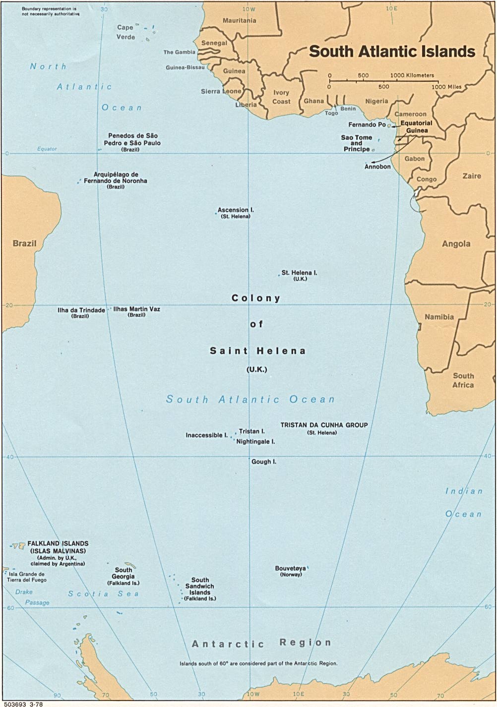
South Atlantic Islands
While putting together a post about Tristan da Cunha that I’m planning for MetaFilter, I came across some very good topographical maps of several South Atlantic islands — namely, the extremely isolated islands along the mid-Atlantic ridge that comprise the St. Helena territory: St. Helena, Tristan da Cunha and its surrounding islands, and Ascension. And don’t miss this pre-1800 collection of St. Helena maps, either. (Via The Cartoonist.)
Wednesday, July 02, 2003
Doctored Maps
Owen Massey follows up on my earlier post about James Turner with a post about doctored maps: one page features the work of Layla Curtis, who makes collage maps from other maps (a map of England from bits of maps of Japan, for example); another flips lands and seas and creates an ocean out of Europe and countries out of the Mediterranean Sea and Atlantic Ocean.
Kazakhstan
My mother’s stepson spends a lot of time in Kazakhstan on business. I hear a bit about out and naturally I’m always interested in hearing more. Last week she and her husband were even invited to a reception in Calgary with the President of Kazakhstan, though in the end Nazarbayev didn’t show up. All of this got me thinking about maps of Kazakhstan, naturally, and I made a lackluster attempt at finding some pages via Google. I needn’t have bothered. Instead, I will write lines: I will always check the Perry-Casteñada Library’s Map Collection first. For, lo and behold, here is Kazakhstan. (And Kyrgyzstan, Tajikistan, Turkmenistan and Uzbekistan, while I’m at it.)
African History
Plep has posted some links he’s been saving up for a while, including a couple of map-related African history links. One, Exploring Africa: An Exhibit of Maps and Travel Narratives, was originally exhibited in 1997: the materials, dating from the 15th Century, are interesting, but the resolution is miniscule, and sometimes blurry — as though the images were taken from a paused VCR. The other is the Perry-Casteñada Library’s Map Collection’s online hoard of contemporary and current historical maps of Africa, which are, of course, marvellous. I’ve mentioned the Perry-Casteñada Library’s map collection before and expect to do so again — very soon, in
 The Map Room is a blog about maps by